Purpose-built software & services for teams that move work forward...Fast!
We help teams and organizations plan, execute, and monitor high-volume field and desk operations—clear workflows, geospatial insight, and reporting that leaders trust.
- Sprint-driven cadence
- GIS-first workflows
- CAMA-aligned forms
Software Solution Spotlight

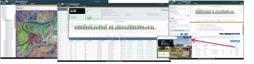
- Sprint-driven cadence: Campaign → weekly sprints → daily routes — planned, assigned, and tracked.
- Open & CAMA-agnostic: Import parcels, generate zones/subzones, build work packages without suite lock-in.
- Forms from CAMA: Build mobile forms directly from CAMA exports for clean in-field data capture.
- Automated comms: Role-aware weekly email of work packages and optimized driving routes that keep field ops on pace.
- Progress intelligence: Burndowns and completion rollups by campaign, sprint, and zone.
GIS Spotlight
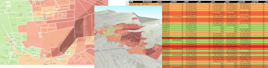
- Parcel shapefile (with slope stats): Parcels retain all original attributes plus slope metrics.
- Native projection preserved: Delivered in the source projected CRS for seamless drop-in to your GIS.
- Excel "Slope Severity" report: A tabular companion to the shapefile containing all parcel attributes and the same slope statistics for quick filtering and summaries.
- Authoritative inputs: Pictured analysis: Slope derived from
Virginia LiDAR Project Inventory; reference imagery: VGIN VBMP 2022 ortho (12-inch resolution). - Ready for analysis & CAMA: Attributes are CAMA-friendly and GIS-ready for joins, thematics, and QA dashboards.
- Transparent lineage: Clear field naming and units (% slope) to support auditability, reproducibility, and map/report generation.
- Map-first deliverables: Symbolize slope severity, export PDFs, and communicate parcel-level risk or access constraints at a glance.
Data Management

GIS & Spatial Data Management
- Reliable parcel foundation: Routine maintenance, topology checks, and version control.
- Authoritative overlays: Managed layers (zoning, flood, districts) aligned to parcels.
- Location-aware workflows: Spatial joins and change detection to guide field and desk work.
- Fast maps, fast decisions: Tuned services and caching for smooth public and internal maps.
- Interoperable by default: Standards-based formats and APIs for easy sharing.
Data Quality, Governance & Compliance
- Clean, consistent data: Profiling, standardization, and deduping to keep records trustworthy.
- Clear rules & ownership: Simple data policies, roles, and workflows that people actually follow.
- Traceable & auditable: Lineage and change history so you know what changed and why.
- Secure by design: Role-based access and privacy-minded handling of sensitive fields.
- Policy alignment: Practices mapped to applicable standards and local requirements.
Reporting, Analytics & Dashboards
- One source of truth: Curated datasets and definitions for consistent metrics.
- Role-based insights: Dashboards tailored for executives, appraisers, and field teams.
- Operational visibility: Workload, throughput, and SLA views to spot bottlenecks early.
- Outcome-focused KPIs: Simple measures that tie effort to results and equity.
- Self-service ready: Governed access so teams can explore safely without IT tickets.
Turcott Consulting LLC — FastAssessor: campaign-driven field ops for assessors.
Contact: info@turcottconsulting.com · www.turcottconsulting.com
Contact: info@turcottconsulting.com · www.turcottconsulting.com